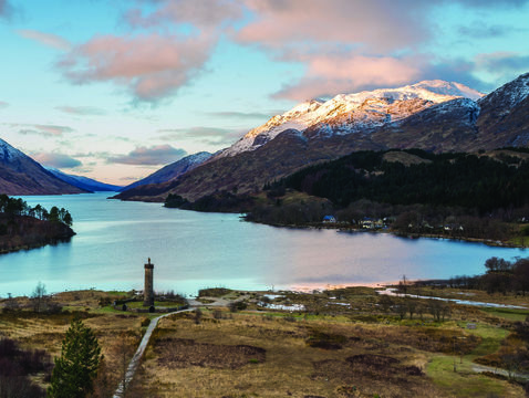
The monument of Glenfinnan, Lochaber.
Dana Huntley went on a 715-mile road trip through the Western Highlands and discovered the most spectacular landscape he’s ever seen.
I have wanted to see the Western Highlands and the Isle of Skye for many years. It takes some time and the right time of year to go, and it is definitely a road trip. Happily, this spring the time had come. My wife, Janet, joined me on a 715-mile road trip through the most spectacular landscape I’ve ever seen.
The world falls away
One of the most sparsely populated areas of Europe, the Western Highlands is the broad region of Scotland that extends northwest of the Great Glen, falling from Inverness, along Loch Ness and the valley running southeast to the Nevis Range of mountains.
A shipwreck run aground next to Fort William in the Scottish Highlands.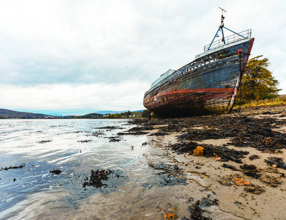

At its base sits the market town of Fort William. With a population of circa 10,000, it is the largest town in the Highlands after the city of Inverness. Looking down on the town is Ben Nevis, Britain’s tallest mountain, still streaked with snow in early May.
Many people get to Fort William walking. It is the terminus of the West Highland Way, claimed as Britain’s most popular long-distance walking trail, stretching 96 miles from Milngavie, north of Glasgow, to Fort William. Others arrive by train on the West Highland Line, which connects Glasgow to Fort William. The rail line runs on to Mallaig, ferry port for crossing to the Isle of Wight.
Coming from Edinburgh, I drove a Vauxhall SUV on the sleek M9 up to Stirling and the ancient town of Dunblane. Built of dark red sandstone, the 12th-century Dunblane Cathedral sits adjacent to a town square that feels remarkably little altered since the cathedral’s heyday. We ate supper on the deck of The Riverside gastropub.
The route northwest leads through the famed and picturesque hills and lochs of The Trossachs. Along the way, we met Hamish, a Highland Cattle bull, and a few of his friends.
This is Rob Roy MacGregor country, where the 18th-century folk hero is buried here beneath the Braes of Balquidder. Turning north and west as the A82 weaves, the arable farmland, pastoral green slopes, and tree-covered hills morph into higher, more angular and rocky peaks.
The broad grassy valley of Glen Coe is popular with hikers of all descriptions, with sheer stone mountain faces on either side. Here in 1692, the massacre of Jacobite Clan MacDonald by Campbells loyal to King William while under MacDonald hospitality is an infamous page of Highland history. A visitors centre of the National Trust for Scotland, near Ballachulish, offers all manner of travelers hospitality, information, and refreshment.
Don’t expect Fort William to be picturesque; this is a gritty working town, and its principal business is visitors, especially trekkers and hikers from around the world. Its pedestrianized stone high street is lined with outfitters, eateries, pubs, woolen shops and suppliers geared to outdoor adventurers. The West Highland Museum sits in the town square and the tourist information centre is a few doors away. One outfitting shop posts a prominent sign: “There’s no such thing as bad weather, only the wrong clothing.” Billy Connolly put it another way: “Scotland has two seasons, winter and June.” Fort William also offered the last McDonald’s or Wetherspoons pub we would see in almost 600 miles of driving.
Over the sea to Skye
Leaving Fort William on the A830 to Mallaig, road signs and most commercial signage is bilingual. Only one percent of Scots speak Gaelic, and they live in the Highlands and Islands, remote glens, crossroad hamlets and villages. I heard it spoken in the conversation for the first time in Fort William, where seven percent of the residents speak the ancient Celtic tongue.
The barren bleakness of the Highland landscape quickly becomes pronounced. The human footprint on this part of the world has trod lightly, but historically.
Thurso, Caithness, Scotland.
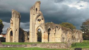
At Glenfinnan on the northern shore of Loch Shiel, in September 1745, Bonnie Prince Charlie raised his standard to rally the clans and ignite the Jacobite Rebellion known as “The ’45” – to disastrous effect for the Western Highlands and its people. The monument at Glenfinnan has drawn visitors and pilgrims for generations. The parking lot was full when we passed. Ironically, most visitors were there to see the dramatic Glenfinnan Viaduct, the rail bridge that is a visual icon of the Harry Potter movies.
It was an hour and a half or so drive to the working harbor town of Mallaig. It is the end of the line, Here, you catch a Caledonian & Macbrayne ferry for the 35-minute crossing of the Strait of Sleat to the Isle of Skye. From the landing at the village of Armadale, the single road leads across the island’s southern Sleat peninsula 20 miles to Broadford Bay.
Skye is 60 miles long. How wide depends upon where you measure the irregular, pocked coastline. The island has a population of 10,000, of which 2,250 live in the island’s capital town of Portree. We put up in Broadford, with 1,300 residents, the second-largest settlement on Skye, at the Dunollie Hotel adjacent to the small harbor. It’s one of few hotels on the island large enough to cater to coach tours. There were two in residence. In addition to a large, comfortable lounge bar for guests, the hotel has a public bar that is the village pub – accessible only via a separate doorway on the street. Our ground-floor room overlooked the bay, some 30 feet from the water. I shot pictures of the sunset at 9:45p.m.
The Cuillin Hills dominate Skye’s geography, two ridges of steep rocky peaks rising abruptly from the sea to 3,200 feet. It’s some of the most difficult climbing terrains in Britain. Most of the rest of Skye’s irregular coastline radiates north, west, and east of The Cuillin.
The next day we drove the circular route of the island, most popular with visitors, under the broad shadows of the stone mountains to Dunvegan. I avoided the turn-off to the distillery of Talliskers, the island’s famed malt whisky.
Dunvegan Castle, at the Isle of Skye.
The village of Dunvegan exists because of Dunvegan Castle, the ancestral home of the chiefs of Clan MacLeod for 800 years. While the castle morphed over the centuries from a defensive fortress and powerbase to a baronial home, the medieval dungeon remains in the heart of the old keep.
Surprisingly, given the northern latitude and bleak climate, extensive and immaculate gardens spread south and east from the house – woodland paths through rock and water gardens, walled gardens and formal gardens. Dunvegan remains today in the chieftain’s family, the residence of Hugh MacLeod of Macleod.
From Dunvegan, it is some 25 miles across the island’s waist to Portree. As the service center of the island, the bustling harbor town feels larger than its numbers, with small hotels and hostels, eateries and woolen shops. The large town square is a marketplace, bus station, and coach park. Portree’s climate and age give the town a weather-beaten, but cheerful, air.
Back at the Dunollie Hotel, we ate dinner in the lounge. A family eating adjacent to us held their conversation in Gaelic. Local musician Ally MacKenzie set up to play. While we heard the bagpipes several times, the Scottish folk music of the Highlands is played with accordion and fiddle.
Ally’s dexterous fingers on the accordion were masterful as he regaled us with Scottish reels, laments and ballads, including loved classics such as The Skye Boat Song and Mary’s Wedding. Later, I went around the corner to the public bar to visit with the locals.
Over the Northwest Passage
A road bridge from Skye to the Kyle of Lochalsh, with both train and road links to Inverness, has existed since 1996. At Loch Alsh, however, we turned north into the wilderness. The popular route of coach tours and outdoor adventurers ends here.
I drove a 240-mile route from the Kyle to Thurso, Britain’s northernmost town. This was two-hand driving all the way. Roads are narrow and there are no hard shoulders. In many places, there are no guard rails where we would, eh, deem them appropriate. Rarely did I drive more than 40 mph, and rarely were there straight lengths of the road as long as a quarter of a mile. At several points, including a 30-mile stretch, the road was single-track with necessary, frequent passing spots. On the maps, this was an “A road” – a primary road. The designation is purely honorary.
The Highland landscape of higgledy-piggledy mountains, lakes, and glens is scenically breathtaking and awe-inspiring. Pictures and movies convey that accurately. The sheer scale of the region, however, is quite unimaginable without experiencing it.
A damp haze hung in the air much of the way lending an ethereal scrim to the atmosphere. Above Loch Carron the moisture cast a faint rainbow over the loch. It was very easy to imagine Brigadoon emerging in the next glen.
People do live here. There are crofting farms scattered on lower hillsides and the occasional flock of sheep; hamlets of several houses gather at a crossroads. A few small country hotels cater to hikers, hunters and the thin passing trade of tourists and officialdom. In the midst of nothing, there would be a long-abandoned small stone church and burial ground – the only testimony left of a population that used to be much larger before the Highland Clearances of the 18th century.
Ullapool, a harbor village of 1,500 people at the eastern end of Loch Broom, is the only town on this western route. It is the ferry port to Stornoway and the Outer Hebrides and has a small fishing fleet. Ullapool serves tourists and visitors with small hotels as well as guest houses and B&Bs. It also provides healthcare and education services for the Western Highlands, and apart from its Tesco, the nearest grocery store is 45 miles east in Inverness.
A weather pattern that had set in by the time we reached Fort William continued as we drove north: rain, sun, repeat. Dark gray clouds swathed the sky with showers and wind off the open North Atlantic, with temperatures in the 30s and lows 40s. Then, the sky would quickly clear to blue and sunny, the wind died down and temperatures rose 10 degrees in as many minutes. Without warning, the next band of clouds would roll across the mountaintops and rain begin again.
At the top of the world
Where the mountains fade into a coastal plane, the market town of Thurso (population 8,000) is the northernmost town on mainland Britain and serves a ferry port to the Orkney Islands. It feels like the top of the world.
We stayed at the Pentland Hotel on the town square, across from the blackened, old red sandstone parish church. The Victorian hotel was full of dark oak woodwork, dry flowers and grasses, and a warm, comfortable air. The more contemporary lounge bar and restaurant were popular with locals.
We’d been told Thurso was renowned for its fish and chips, and it proved justified at the Pentland, with a huge fillet of haddock fresh off the boat that morning and perfectly fried. While we walked around the square, it was hailing.
It was 20 miles the next morning up along the coast to John O’Groats at the tip of the island and the Highlands – “the first and last of Britain.” At the location itself, there’s a small harbor with a ferry over to Stromness, Orkney, a rustic looking inn and a couple of cafes and gift shops.
We were 130 miles north of Inverness. The A9 south was much better and busier than we had seen, but the hairpin turns and roller-coaster landscapes still made that a three-hour drive with gorgeous seascapes on one side and the mountains to the other. And there are towns. At Golspie, Dunrobin Castle is the seat of the Earl of Sutherland and a popular visit. Passing Invergordon, we could see half a dozen oil rigs mothballed in Cromarty Firth until the market changes for North Sea oil.
Inverness is the capital of the Highlands, with 65,000 people in the northernmost city in Britain. It is also the city for a vast part of Northern Britain, providing urban services and amenities and connecting the Highlands to the world by air and rail. By train, it is three and a half hours south through the Cairngorm Mountains to Edinburgh. You can take the Caledonian Sleeper any night and wake up in London the next morning. We dropped the car off and caught a train on the Grampian Line across northern Scotland’s rolling farm country to Aberdeen. Back in “civilization.” I’ll catch Brigadoon next time.
* Originally published in 2020.


Comments