Volcanoes of SkyeGetty images
The Isle of Skye is incredible.
Some places just exist to be looked at, the sort of places where museums or restaurants or shopping are strictly bonuses. You are there to stare at scenery so spectacular that you can never get tired of it, and so unusual that you will never find anything else like it. In Scotland, the place for this is the Isle of Skye.
The largest of the chain of islands known as the Inner Hebrides, Skye sits a scant 2,000 feet off the western coast of the Scottish Highlands. It’s an 80-mile drive from Inverness, which Google Maps optimistically (and quite erroneously) thinks you can do in an hour and three-quarters. On this drive you will enjoy the sort of spectacular scenery found throughout the Highlands, the ordinary level of extraordinary beauty.
You will pass through many miles of rolling emptiness, boggy hills covered with rough bracken and heather, dotted with sheep, and very beautiful in an austere sort of way. You will drive along the banks of long, skinny lochs (including Loch Ness) and fjords carved by glaciers as they oozed out of their mountain fastnesses like toothpaste from a tube. You will pass the mountain flanks carved into vertical cliffs by those glaciers. And you will pass the castles built to guard the narrow passes, including dramatic Urquhart Castle on Loch Ness, and the beloved film location of Eilean Donan. There is, however, one thing you won’t see along this drive until you cross that bridge onto the Isle of Skye: volcanoes. In the (geologically) not-too-distant past Skye had them, and today Skye possesses an astonishing variety of stunning and dramatic volcanic scenery.
Let’s start at the far north of the island, 50 miles from the bridge to the mainland. Here you’ll find a peninsula, 20 miles long and about nine miles wide, known as Trotternish. (Much of Skye consists of long peninsulas with names ending in -nish.) It’s an old lava flow, with a backbone ridge of volcanic basalt facing eastward as a line of cliffs. And what cliffs! Basalt’s characteristic verticality has eroded into a series of hoodoos that stretch in a line along the center of Trotternish, reaching a climax at the strange group of formations known as The Quiraing. In 1865 traveler Alexander Smith called it “a nightmare of nature, frozen terror and superstition…. This is a huge spire or cathedral of rock some thousand feet in height, with rocky spires or needles sticking out of it. The country around is strange and abnormal, rising into rocky ridges here, like the spine of some huge animal, sinking into hollows there, with pools in the hollows.”
This formation ends abruptly at a platform paralleling the sea, dotted with pretty little farms and handsome cottages, the classic pastoral scenery of Scottish crofts. Then comes more basaltic cliffs rising straight out of the sea in vertical columns, shaped into octagons so regular as to appear to have been carved. At Kilt Rock the cliffs exceed 300 feet in height, and the waterfall of Loch Mealt flows straight over them. An excellent overlook along the main road gives fine views; then, three miles north, a side lane leads east nearly to the top of The Quiraing itself.
The basalt flows continue 30 miles to the west of Trotternish, forming the peninsulas of Waternish and Duirnish.
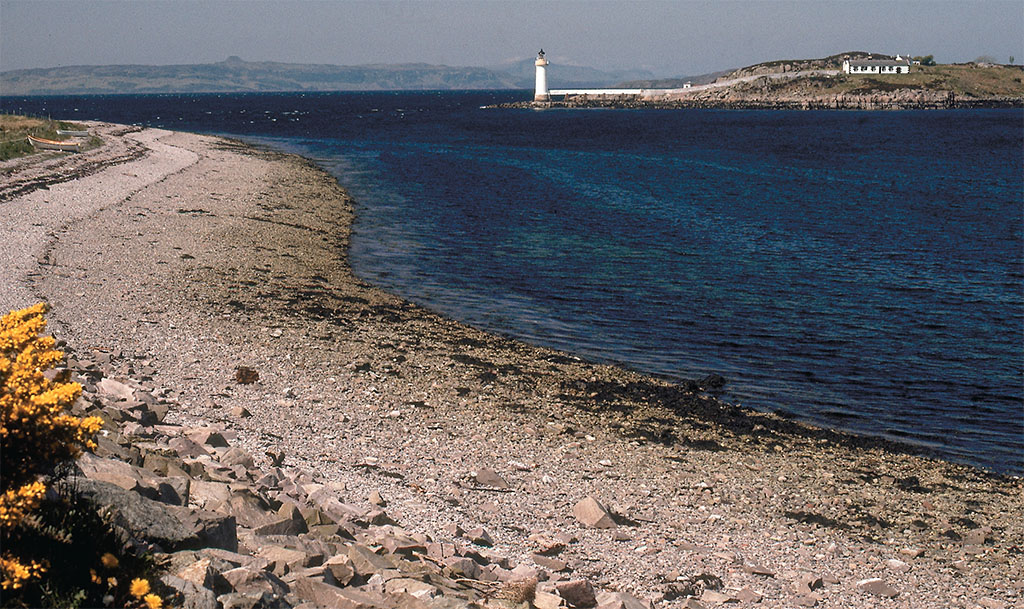
Waternish comes first, known for its traditional crofting landscapes and its 12th-century castle at Dunvegan, still the seat of Clan MacLeod after 800 years. Duirnish, further west, has sea cliffs, including Waterstein Head, the tallest in Skye at 976 feet, and the tallest in Scotland that can be reached without a ferry crossing. Opposite the cliff is Neist Point with its classic lighthouse. Reached by a three-quarter mile concrete-paved path, the lighthouse sits atop more of those basalt columns, and gives excellent views over to Waterstein Head. Legend claims that Neist Point’s basalt columns are the remains of a road that was flooded by the Irish Sea and emerges as The Giant’s Causeway in County Antrim.

JIM HARGAN
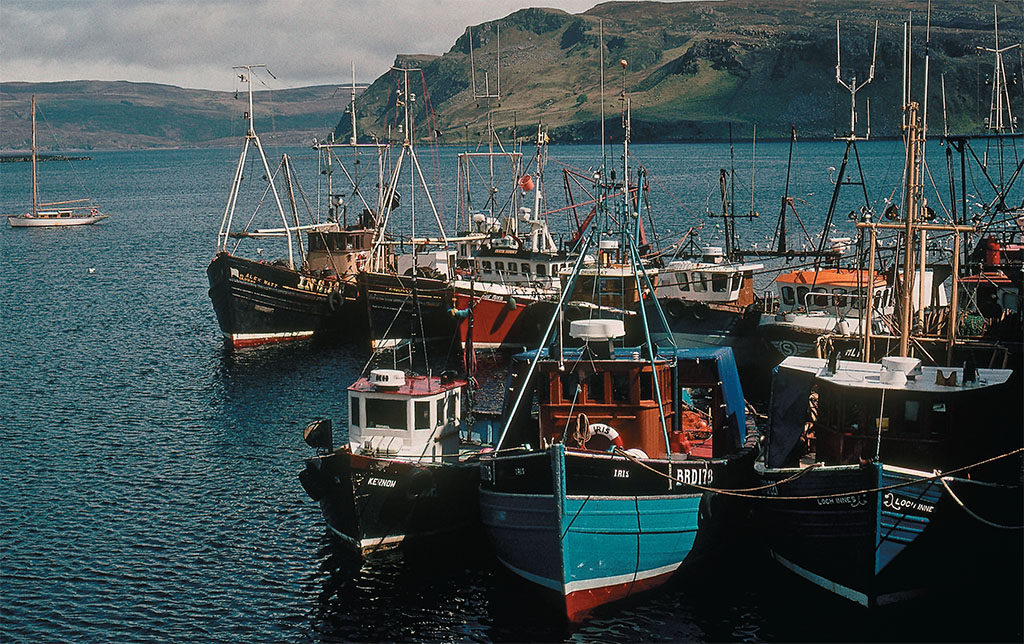
On the southern edge of Trotternish, the glaciers have carved a notch in the basalt cliffs, and here nestles Skye’s main town and finest manmade sight, the harbor town of Portree. Its L-shaped harbor, designed by Thomas Telford, stretches for 1,000 feet, lined by brightly painted cottages sheltered by the dark cliffs immediately above; in the summer, it’s crowded with small boats. Here you’ll find shops, cafes and little hotels, with steps climbing the low cliffs. The northern side of the harbor, however, offers the best scenery, as Scorrybreac Road becomes a footpath that circles the volcano’s final lava flow, Ben Chracaig, with stunning views. A side trip seaward at the top of the path leads you deep (and rather dangerously) into this relic flow, for a last look at the weird basaltic scenery on its craggy top.
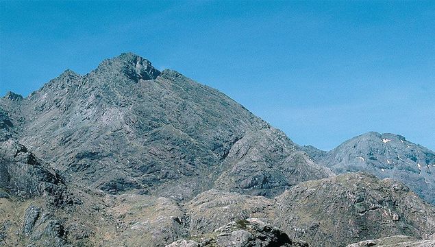
For the volcanoes themselves, you’ll need to drive about 25 miles south of Portree, to the Cuillin Hills, a long mountainous arc to the south (and out of sight) of the island’s main highway. Don’t let the term “Hills” deceive you; these include the most rugged peaks in Britain. The western “hills” are known as the Black Cuillin, a range of hard, black gabbro, carved into a miniature Alpine range by glaciers. Unique among the mountains of Scotland, the Black Cuillin are so cliff-bound that peaks (with one exception) are not accessible without mountaineering equipment—yet paths penetrate far into this roadless maze. The finest walking is around Loch Coruisk, in the center of the mountains and ringed by a gapless wall of mountains; Sir Walter Scott called it “…that dread lake / With its dark ledge of barren stone,” and J.M.W. Turner painted it with the surrounding peaks appearing as storm-driven waves. A lane so narrow that it is easily mistaken for a driveway follows the western foot of the Blacks for eight miles, leading to many trailheads before dead-ending at a lovely sand beach with stunning views back towards the mountains.
The Cuillins are split through the middle by the flat, boggy valley of Glen Sligachan (bulldozed by a glacier during the last Ice Age), a stunning and remote trench accessible only by foot, with remarkable views of the surrounding peaks. Then the Cuillins continue—but with a completely different character. Now they are The Red Cuillin, every bit as tall as the Blacks, but made of granite instead of gabbro, and rounded, with talus-covered slopes. A narrow lane leaves the main highway just seven miles west of the mainland bridge to pierce the heart of the Red Cuillin, ending 15 miles later at the waters-edge crofting village of Elgol.
At the 11-mile mark, a farm track, closed to vehicles but open to hikers, turns off to the west, climbing 600 feet to cross a low shoulder of the Red Cuillin’s largest peak, Bla Bheinn, then dropping back to the sea at the remote beach of Camasunary in 2.5 miles. Here you’ll find a tidy little cottage set in a green sward, surrounded by massive peaks—the lumpy mass of Bla Bheinn behind you, the jagged peaks of the Black Cuillin in front. Running northward from the cottage, a track follows the gorge-like valley of Srath na Creitheach, separating the Reds on your right from the Blacks on your left, and from it other, more obscure, paths lead up towards Bla Bheinn or over a ridge to Loch Coruisk. It’s a fine place to enjoy the volcanoes of Skye.
JIM HARGAN
* Originally published in 2016.

Comments