roaming with the Romans
[caption id="TimelineAD122_img1" align="aligncenter" width="1024"]

YVONNE MICHIE HORN
THERE IS SOMETHING ever so satisfying in walking the entirety of a designated trail, especially one for which boots must be laced up and later eased off the weary feet. Hadrian’s Wall Path—at No. 13, England’s newest long-distance National Trail—rates high in that sort of trekking satisfaction as it winds its way across northern England, east to west, sea to sea.
Diversity of landscape adds to the sense of odyssey experienced by those walking the path’s 84-mile distance—wild and beautiful in some portions, serenely pastoral in others; a bustling city, Newcastle upon Tyne, at its start; a lonely shore with the cries of gulls and the gentle lap of the tide marking its end at Solway Firth. Added to that is the opportunity to tread an amazing chunk of history.
Hadrian’s Wall has always fascinated trekkers. In 1801, one William Hutton, hailing from Birmingham, walked its length, turned around and walked it back again. He was 78 years old. Historians grouse that, while his account is lively, he got a lot of stuff wrong.
A lot of trekkers still get it wrong. Built by order of the Roman emperor Hadrian, who came to Britain in AD 122, it was not, as so often supposed, an ancient-world variation of the Berlin Wall. It was devised as a system for controlling movement, not preventing it. Fortified gates, “milecastles,&dsquo; were placed at every mile, allowing for the passage of people and regulation of trade north and south, while undoubtedly extracting a price for the privilege. When “barbaric” clans from the north acted up, Rome’s legions, representing “the superior civilization from the south,” simply marched through the gates to let them know who was who and what was what with a good smacking.
One can imagine the apprehension of the local populace as the wall began its inexorable crawl across hill and dale—12 feet high and 10 feet wide at its base, with some sections built entirely of stone, others as an even wider and higher wall of turf. What might they be up to? As the years went by—nearly 400 of them before the Romans packed up and left—the wall became just another part of the landscape. Civilian settlements thrived around the gates resulting in the usual mix of marriages and progeny, blurring north and south, Romans and “barbarians.”
While purist trekkers would insist on walking every step of the designated pathway, most visiting Hadrian’s Wall lack either the inclination, stamina or time to hike its entire distance. Fortunately, the Hadrian’s Wall Tourism Partnership, a consortium of diverse entities interested in promoting the trail, has made it easy to follow bits and pieces of the path. Options abound. Hadrian’s Wall Bus Service runs a hop-on-and-off timetable to designated featured sites and has integrated it well with rail service. A Walking and Accommodation Guide lists plentiful B&B’s within close distance of the wall; most are willing to transport guests’baggage to their next night’s stay—handy for those walking all or several consecutive sections of the trail. More than three dozen short, circular routes lure walkers to forts, museums and other Roman heritage sites off the trail.
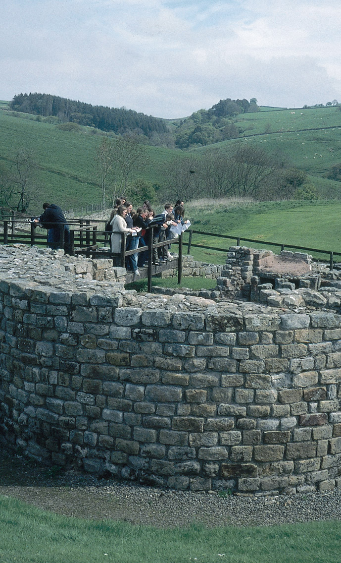
The section of the wall that lies within the boundaries of the Northumberland National Park, midway along the trail, is the best place to imagine what the wall was like during the time of the Romans. With but one afternoon at my disposal, I pulled into Steel Rigg car park to walk a portion of the wall “backwards,” west to east—contrary to the direction that guides to the path are written—so as to have the wind at my back.
From Steel Rigg, the view of the wall is breathtaking, wandering up and down over crags and moor, snaking away in the distance. Few miles have remained so intact.
While some of the wall’s tumbling away can be credited to centuries of natural deterioration, according to park ranger Page Lazzari, who walked the section from Steel Rigg with me, large pieces of the wall were taken as a ready supply of building material after the Romans’ departure. As Lazzari explained, “Why bother to start from scratch at the quarry when plentiful handcrafted stones were right under your nose?” Farmhouses and castles along the route, even the 12th-century crypt below the parish church in nearby Hexham, were constructed of stones carted away from the wall. In Hexham, the church steward who guided me down the steep steps into the crypt preferred to refer to the pilfering as “recycling.”
In 1754, with total disregard for history, much of a new road, known today as B6318, took over a section of the wall. “That act of official vandalism aroused the start of a conservation movement,” Lazzari related as we walked along. It was a movement that took 350 years and &doller;9.5 million before Hadrian’s Wall, a designated World Heritage Site, became a protected long-distance footpath.
Steep rises and falls in the terrain gave our legs a workout as we followed the wall of tightly fitted gray stones. Rough stone steps eased the way to top-of-the-world views, with Scotland but three miles distant. At one high point we looked straight down into lovely Crag Lough where a pair of swans drifted over the still water. We passed through remnants of three milecastles, each built to hold postings of as many as 32 men, with never less than two walking the wall on patrol night and day.
“What is gone from the wall is gone,” Lazzari commented, as we paused to read a sign requesting walkers to stay on the path and never, ever, however tempted, climb up on the wall. “But what is left has been here for nearly 2,000 years. With proper care it could be with us another 2,000.”
Most purist walkers of the trail would probably entertain no deviations from the main route so as to claim a start-to-finish tracing of the official path. My ranger companion, however, encouraged me to take one of the off-path circular routes in order to visit Vindolanda, a Roman fort located one mile south of the wall.
A dozen forts, roughly placed at seven-mile intervals, were established to protect the wall, some built astride, others constructed close by. Vindolanda, however, predates the wall by a good 45 years.
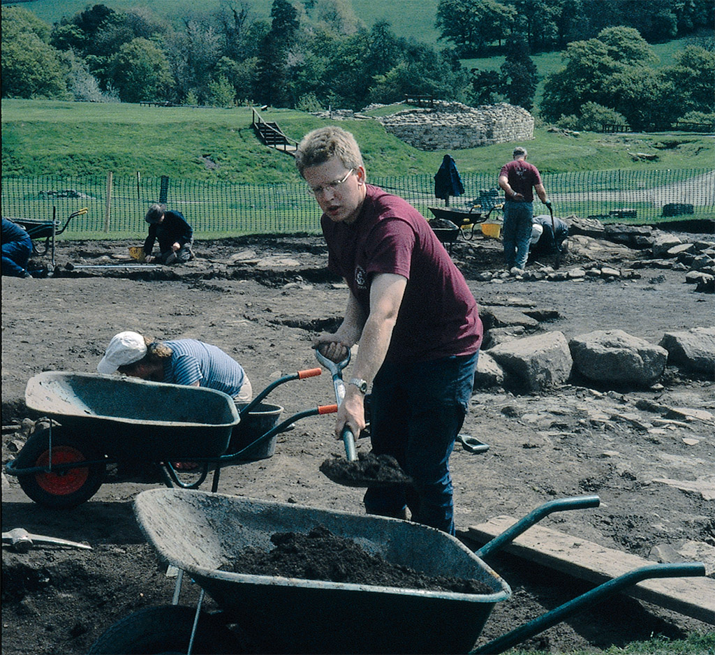
Archaeological excavation has been ongoing on the 15-acre grounds since 1970 with the end nowhere in sight. Finds include an elaborate commanding of®cer’s residence, temples, entrance portals, bathhouse and latrine facilities with flushing water, along with a well-marked civilian settlement that grew up around the fortress to provide essential—and sometimes dubious—services. A huge amount of material of all kinds emerged, most documenting everyday life: shoes, pots and glassware, the surprise of a ladies wig, a cat caught in a floor heating system.
[caption id="TimelineAD122_img2" align="aligncenter" width="689"]
YVONNE MICHIE HORN
Rare examples of Roman writing, on thin sheets of wood—the stationery of the day—were found preserved in the anaerobic soil. The British Museum, where the Vindolanda writing tablets are now housed, considers them among its top 10 treasures. The writings are not of the “Hail Caesar” sort, but are instead ordinary pieces of correspondence: Thank you letters—“through your kindness we are able to celebrate the holidays more splendidly”; requests for leave; explanations—“I would have fetched the ox hide but the roads are bad”; letters of recommendation; complaints about the local population, the Brittunculi, the wretched Britons. More than 1,000 tablets have been recovered. A small museum displays replicas along with a host of other unearthed items. In the garden outside the museum, a memorial stone honors those who served at Vindolanda from AD 85±450.
From Vindolanda, I circled back to the car park. While my boots had not taken me far along the route of Hadrian’s Wall, they had nevertheless taken me deep. In a single afternoon, I’d trod the heart of a remarkable monument and traveled 2,000 years.
IF YOU GO: Hadrian’s Wall Bus Service timetables, tickets and fare information are available from Hadrian’s Wall Information Line: Phone 01434 322002, E-mail [email protected]; Web site www.hadrians-wall.org. Hadrian’s Wall Tourism Partnership offers a series of helpful publications available by mail order from www.offasdyke.demon.co.uk. Other regional information is available from Northumbria Tourist Board:
www.visitnorthumbria.com; Cumbria Tourist Board: www.golakes.co.uk; and Northumberland National Park Authority:
www.northumberland-national-park.org.uk. Information about Vindolanda can be had at www.vindolanda.com.
The National Trail Guide: Hadrian’s Wall Path, by Anthony Burton, is the official guidebook to the path.


Comments