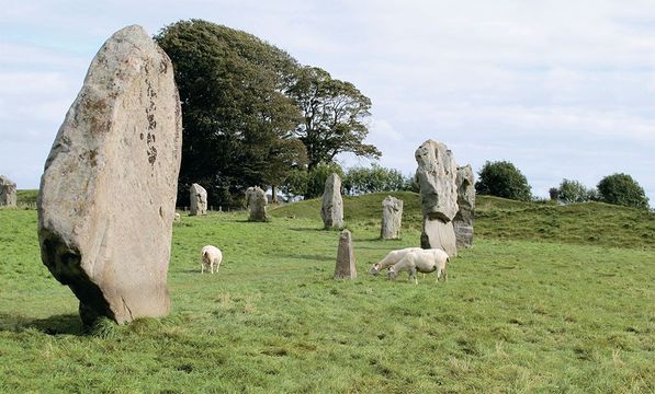
Sheep contentedly graze among the stones of Avebury.Sian Ellis.
The chalk route has taken folk across southern England since the Bronze Age.
Ancient man wasn’t daft. Or if he was, he was soon dead. If he needed to get from A to B, for example, he took the easiest, safest route. The chalk ridge that runs from England’s south coast to Norfolk provided one such natural choice: high, dry, and with good views for spotting danger. Indeed what we know today as the Ridgeway once formed part of a trading route from the Devon coast to Norfolk’s Wash, giving access to the heart of England and linking with other important arteries like the Icknield Way and River Thames. It’s often described as Britain’s oldest highway.
But how old is old? The Anglo-Saxons already considered it ancient, a type of path known as a hyrcgweg (ridgeway). Rich archaeological sites en route suggest it served many settlements, being used for transporting materials around from the earliest times. There are Neolithic and Bronze Age long barrows, Iron Age hill forts, discoveries of stone axes from as far away as the Lake District, and pots made with clays from Cornwall.
During the Anglo-Saxon era, native and Viking feet pounded the Ridgeway, squaring up for battles in the kingdom of Wessex; in the Middle Ages, drovers bustled their livestock along the top of the downs from the West Country and Wales to sell in middle England. There was considerable scope for wending and wandering to pick the least muddy, cumbersome way—only with the 18th-century Enclosure Acts that parcelled up the old common land between owners was the Ridgeway specifically defined between earth banks and hedges.
Today, the Ridgeway is a leisure route for walkers, but, remarkably, the sense of the original functional blueprint has never been discarded. The M4, the major artery east-west across southern England, echoes the ancient route for some way a few miles to the south, while settlements in the shape of desirable London commuter-belt towns and villages still hang like so many seductive baubles off the Ridgeway, along the spring line at its foot.


A map of the Ridgeway National Trail.
The 87-mile Ridgeway National Trail (opened in 1973) follows the original prehistoric chalk track—with divergences here and there—from Overton Hill in Wiltshire to Ivinghoe Beacon in Buckinghamshire. Whether you ramble it all (allow a week including a day of rest) or dive off the M4 or M40 from London to cherry-pick some of its attractions, you’ll reel in a ribbon of historic sights: framed in open-skied chalk downland to the west and the cozier embrace of Chiltern woodlands to the east. Start in the west to work with the prevailing winds, should they blow!
The first highlight comes just a little before the official start of the modern trail, but it’s simply too good to miss. Avebury henge (bank and ditch) and stone circles in Wiltshire form part of the mysterious sacred landscape, now a World Heritage Site, that fans out to Stonehenge 16 miles away. It’s a challenge to grasp Avebury’s overall scheme when you’re exploring on foot. The ditch encloses an area of 28.5 acres and a circle of giant gnarled standing stones, which in turn encloses two smaller stone circles—with part of Avebury village and a lively modern road bang in the middle of the ancient scene. But drop in to the Alexander Keiller Museum, set up by a marmalade millionaire who excavated the site in the 1930s, and you’ll get a good overview.

Relicts of every age line the Ridgeway, like the 15th-century parish church of St. Mary the Virgin at Bishopstone.
Created circa 2,850–2,200 BC, Avebury is a mind-blowing Neolithic complex; just imagine how it looked when the now-grassy chalk ditches dazzled white and the full complement of 100 or so stones stood in the outer circle. Just imagine the thousands upon thousands of hours’ labor to drag the sarsen stones from the local downland and into place. For what ritual purpose? Today, grazing sheep use the stones as back-scratchers, depositing puffs of wool across the grass; human visitors scratch their heads and seek inspiration in The Red Lion pub overlooking the megaliths.
Just down the road, Europe’s largest manmade mound, Neolithic Silbury Hill, swells nearly 100 feet into the sky, though what vision was served by the 4 million man-hours of work it took to build it, no one knows. Further on again, the official start of the Ridgeway at Overton Hill once boasted a henge linked by an avenue of stones to Avebury.
From Overton, it’s a breezy swoop by foot or car up Hackpen Hill, past the white horse (looking more like a playful dog) carved into the chalk in 1837 to commemorate Queen Victoria’s coronation. Then, 6th-century Barbury Castle is our first encounter with the numerous hill forts that made the most of the strategic advantages of the Ridgeway. Visit when early morning or late afternoon shadows cast the double ramparts and ditch of the Iron Age refuge into sharp relief; then also, the distant sight of modern Swindon becomes a grey-brown smudge blending with handsome views of open countryside.
The most famous hill fort en route is Iron Age Uffington Castle, 860 feet above sea level and the highest point in Oxfordshire. The chalk path up White Horse Hill to reach it gleams underfoot and, once across ditch and rampart, you find the fort flattens into a surprisingly expansive plateau.
Yet the fort is almost relegated to mere backdrop for the famous Uffington White Horse that leaps across the hill at the head of the valley, a match for any modern-day racehorse training on the nearby Lambourn Gallops. The highly stylized creature, some 365 feet from nostril to hoof, would not look out of place in a review of 21st-century art; investigations in the 1990s, though, have shown it to date from the Bronze Age, making it the oldest of all the white horses that canter around southern England’s hillsides (see British Heritage “All the White Horses,” January 2013, pg. 30). Was it carved by worshippers of the sun god Belinos, who was closely associated with horses? Certainly, a god with an aerial viewpoint could best appreciate the handiwork: up close, it appears just a bold, abstract pattern.
Directly below the white horse and castle, the air veritably twitches with ancestral mystery, adding to the sense that this was a truly significant site: if we only understood why! To the right is Dragon Hill, round and flat-topped with a white chalk scar allegedly left by the taint of blood where St. George killed the dragon. To the left, The Manger is Nature’s creative contribution: a dry valley with sides rippled into “Giant’s Steps” by retreating permafrost during the last Ice Age. Beyond, the views stretch for miles and even the fuzzy vision of Didcot Power Station’s white-plumed chimneys takes on a surreal artistry.
Hooray for Henley
 6
6
Henley’s 1901 town hall centers a pretty piazza hosting festive markets throughout the year.

Henley’s 1901 town hall centers a pretty piazza hosting festive markets throughout the year.
Fashionable Henley-on-Thames, on the edge of the Chiltern Hills and half a dozen miles south of the Ridgeway Path, is a must-visit if you are here between July 3-7, 2013 when the world-famous Henley Royal Regatta takes to the River Thames.
With up to 90 races a day over the one mile, 550-yard course (112 meters longer than the standard international distance of 2,000 meters), it’s a rowing bonanza and a highlight of the summer social season: floaty frocks (hemlines strictly below the knee in the Stewards’ Enclosure), lounge suits or blazers and flannels are de rigueur for spectators wanting to cut a dash.
Read more
The Leander Club, home of British rowing and many an Olympic gold medallist stand close to the regatta finishing line, while a toddle along to the River and Rowing Museum in Mill Meadows reveals interesting stories of the Thames, rowing, and the town.
Aside from river sport, Henley (population 10,500) boasts year-round markets and festivals. Get a town trail from the tourist information center in the handsome 1901 Town Hall and explore. The oldest building is The Old Bell pub in Bell Street, dated to 1325; the most charming thoroughfare is New Street where half-timbered houses and 18th-century brick edifices mix and match; the most-photographed vista is The Angel on the Bridge—pop in for a pint and spot the brass plaque on the floor, “Princess Grace stood here”: In 1947 the then aspiring actress came to celebrate her brother’s regatta victory in the diamond skulls race.
www.henley-on-thames.org
If you’re rambling the Ridgeway, you’ll have already passed Wayland’s Smithy, otherwise, it’s a 20-minute (1.4-mile) walk back along hedged lanes from Uffington Castle and the car park there. The grassy tump of Wayland’s Smithy, flanked by sarsen stones hauled here from the Marlborough Downs, forms a Neolithic long barrow, where research has found remains of 14 human burials. Legend bows to the local equine theme with the tale that if you leave your horse and a coin overnight, by next morning the Saxon smith god Wayland will have re-shod your steed. You may not get walking boots repaired, but the sun-dappled site amid beech trees makes an unusual, peaceful picnic spot.
Villages all along this stretch of the Ridgeway—Bishopstone, Idstone, Ashbury—present gentle rural vignettes of thatched cottage, church, pond, and pub. There are some royal connections to look up, too. Ashdown House, Lambourn, is a beguiling doll’s house of a home in the Dutch style, built by the Earl of Craven in 1662. He intended it to be a country palace for the woman he secretly loved, King James I’s daughter Elizabeth, the Winter Queen (she reigned in Bohemia for just one year before being widowed). Sadly, Elizabeth died before Ashdown was completed and Lord Craven remained a bachelor, though he lived to be 89.
Farther north, the Ridgeway runs close to Wantage, birthplace in 849 of Alfred the Great, King of Wessex—a statue in the market square commemorates his celebrated victory over the Danes in 871. Later moves to consolidate the kingdom of Wessex included putting four important transport routes under royal protection, including the Ridgeway and Icknield Way that also ran to Norfolk.
At around 43 miles (nearly halfway) into our Ridgeway jaunt, the chalk hill is cut through by the River Thames—the so-called Goring Gap. On one side of the river stands the village of Streatley, the county of Berkshire and the North Wessex Downs; on the other stands Goring, Oxfordshire and the Chilterns. There have been settlements here for at least 5,000 years, on the junction of the Ridgeway, Icknield Way and Thames, and a healthy rivalry has played out. In the 8th century, Streatley was in Wessex and ruled by King Ine, while Goring in Mercia was under King Offa, although King Alfred effectively merged the two kingdoms.

The Angel on the Bridge at Henley offers a great vantage for watching the rowing on the river.
CHALKING UP THE RIDGEWAY
NATIONAL TRAIL START
Overton Hill, Wiltshire–from London drive along the M4, leaving at Junction 15 onto the A346 to Marlborough, then it’s the A4. (Keep on going for Silbury Hill and Avebury along the A4361.) Nearest rail station is Swindon, a dozen miles away.
FINISH: Ivinghoe Beacon–from London follow the A1, A41 and B488. (A40 from London then A413 takes you to Wendover.) Nearest rail station for Ivinghoe is Tring, three miles away, and there are direct London trains to Wendover.
Trail information, including maps, accommodation and tour operators, may be found at www.nationaltrail.co.uk/ridgeway. For rail journey planning, www.nationalrail.co.uk.

Boats moored along the river at Streatley include an ornate former college barge.
The Thames Valley is far more genteel nowadays, with wealthy neighbors returning to their attractive brick and flint cottages after a day’s toil in London likely to share a gin and tonic. There are some goodly historic pubs like the pretty 16th-century Catherine Wheel and the John Barleycorn, which has served ale since 1810. The Miller of Mansfield offers five-star British cuisine, and you can hire a boat from The Swan at Streatley hotel/restaurant to “mess about on the river.” Or simply watch others negotiating scenic Goring Lock. There’s an annual summer regatta, though not as famous as the one at Henley-on-Thames—an alluring diversion if you’re in this neck of the woods in early July.
Heading northward, the Ridgeway path rambles along through Chiltern beechwood hills that were once busy with 18th/19th-century bodgers—men working with pole lathes turning out chairs and other bits and pieces. Take another diversion to High Wycombe, former “chair making capital of the world,” for a museum that tells the story.
Back en route, there’s 17th-century Princes Risborough Manor House and a glimpse of Chequers to come. The latter, of course, is the official country residence of the Prime Minister, and the Ridgeway crosses the Victory Drive where Sir Winston Churchill planted beech trees in the 1960s.
Eventually our trail climbs to its conclusion at Ivinghoe Beacon near Tring and invigorating views of the Vale of Aylesbury, plus the option of continuing along the Icknield Way Path many more miles to Knettishall Heath near Thetford. Of course, you could just stop 10 miles earlier at the market town of Wendover in a crease of the Chiltern Hills, another haunt of London commuters with cash to splash on period properties and cute cottages.
The Ridgeway path slips down Wendover’s High Street, flanked by antique and art shops, and the Red Lion Hotel where Cromwell stayed and addressed his troops from an upstairs window. The curious Victorian clock tower, formerly a fire station, gaol, market hall, and now housing the Tourist Information Office, stocks bumph to help you make the most of a short browse. St. Mary’s Church is the oldest building in town, boasting features back to the 13th century.
Ancient man set out along England’s chalk ridges with eminently practical intentions and he would have been baffled at the idea of walking the Ridgeway for fun. But his legacy, explored via the modern day trail, offers a highway of fine historic interest and panoramas.


Comments